Chinese Tariff Rollback: What Does It Mean for Communities Across Canada?
Ricardo Chejfec


As part of the IRPP’s Community Transformations Project, we’ve thought a lot about how external shocks can disproportionately affect local workforces. Even when the shock seems manageable at the national level, it can significantly disrupt economic activity in certain communities across the country, with potentially long-lasting social and economic consequences.
Our work has largely focused on the potential for workforce disruption from global and domestic efforts to reduce greenhouse-gas emissions. Using a new methodology and interactive map, we identified communities where a large proportion of the workforce is employed in sectors or industries most likely to be affected by the global energy transition. We are also publishing a series of related community stories and policy briefs that provide recommendations to governments.
We focused on communities because the potential for workforce disruption is greatest in areas with higher concentrations of employment in certain sectors. In these communities, it is not just workers directly employed at affected companies that face disruption; it can include everyone from local suppliers to restaurants.
With the emergence of an escalating trade battle with our largest trading partner, we adapted our methodology to look at community susceptibility to workforce disruption from tariffs. U.S. tariffs could have significant impacts on workers in communities with high proportions of employment in sectors dependent on exports to the U.S.
While uncertainty looms over tariff levels and the goods to which they could apply, our dashboards allow users to identify communities with concentrations of employment in the targeted sectors. Governments can use this information to inform programs that soften the blow of tariffs and to help communities diversify their economies and reduce their exposure.
The analysis
The two dashboards below show the results of our analysis. We used census divisions as a proxy for communities. Workforce exposure to U.S. exports refers to a community’s average industry exposure, weighted for share of employment in each industry. Industry exposure is equal to the value of an industry’s U.S. exports as a share of output in 2021 for goods-exporting industries, and 0 for all other industries. Employment data is derived from the 2021 census (table 98-10-0592-01) and industry data is derived from the supply and use tables (tables 12-10-0100-01 and 36-10-0488-01).
Why use interactive figures? Canada has 293 census divisions and most of them employ at least one worker in more than 10 goods-exporting industries. The dashboards are the easiest way to explore and convey our findings. Uncertainty over which products will be impacted and by how much also favour the use of more flexible tools.
Some caveats
Many of the caveats described in our methodology for measuring susceptibility to workforce disruption apply here too. Our industry exposure metric is based on national averages, which don’t necessarily reflect actual trade in census divisions. Some communities may have a lot of employment in highly exposed industries at the national level, but these same industries may not be as exposed at the local level.
Census data also has its limitations. Some census divisions are too large and sparse to be good proxies for communities, and employment counts for certain industries are not available in disaggregated form (like crop and animal production).
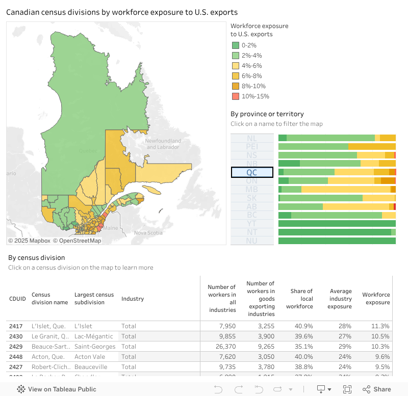
Dashboard 1: Map of workforce exposure to US exports by census division
This dashboard shows a map of Canadian provinces and territories by census divisions, coloured according to their estimated workforce exposure to US exports in 2021. Clicking on the names of provinces or territories on the right will filter the view on it (holding control will let you pick more than one). The bar chart next to them shows the share of their total workforce living in census divisions across the 6 exposure categories.
The table below lists all census divisions in the province or territory selected, ordered by workforce exposure to US exports. To learn more about a census division, click on it on the map and the table will expand to show the top 4 industries contributing to the census division’s workforce exposure score. You can view the dashboard in full screen by clicking the button in the bottom right corner, next to ‘Share’.
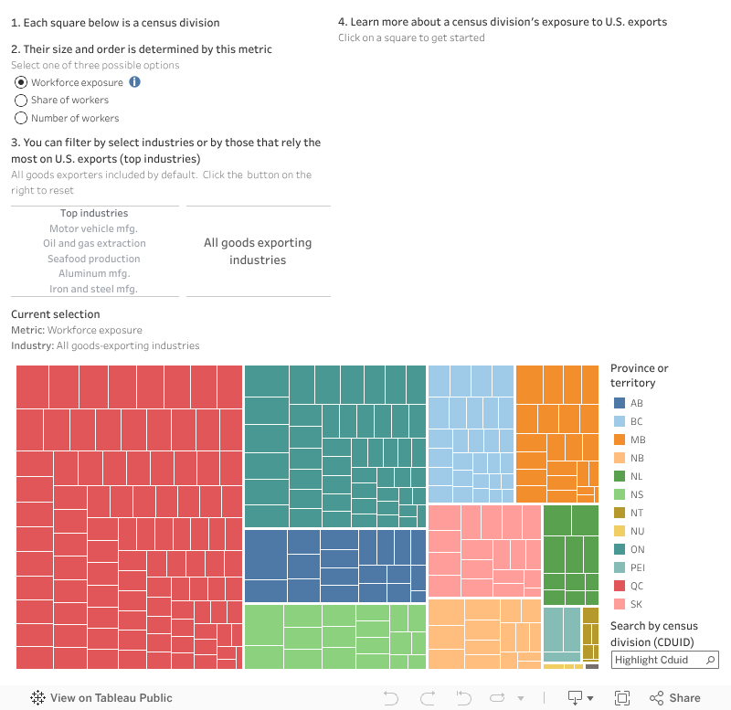
Dashboard 2. Breakdown of workforce exposure to U.S. exports by census division
Based on the same data set, this dashboard shows all 293 census divisions in Canada.
Each square represents a census division. Its size is determined by the metric selected. By default, it is set to show workforce exposure to U.S. exports, but users can also choose to arrange the data by the number of workers or share of the local workforce.
Users can focus on specific industries or groups of industries by clicking on their names. Industries were selected because of a combination of high exposure and large concentrations of employment across census divisions. Top industries are all goods-exporting industries for which U.S. exports compromised more than 40 per cent of output in 2021
Click on a census division (square) to learn more. Search for a census division in the map by using the search bar on the bottom right. You can view the dashboard in full screen by clicking the button in the bottom right corner, next to ‘Share’.
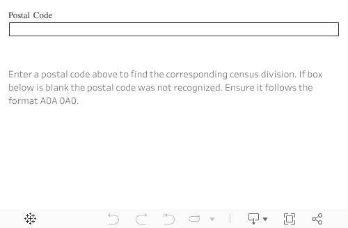
Box 1. Finding your community
All census divisions are identified by a four-digit number referred to as a “census division unique identifier,” or CDUID. To find the CDUID of the census division you reside in, you can use the following form. For more information, consult Statistics Canada’s GeoSearch tool.
Montreal – As trade tensions between Canada and the U.S. continue to escalate, researchers at the Institute for Research on Public Policy (IRPP) have unveiled a series of interactive dashboards to track how dependent the workforces of communities across Canada are on U.S. exports.
The dashboards are designed for policymakers, economic development organizations, industry leaders and residents who want to assess a community’s risks and strengths in the face of potential tariffs from the U.S.
“Canada’s reliance on the U.S. market has left certain communities vulnerable to shifting trade policies, including tariffs and protectionist measures,” said Rachel Samson, the IRPP’s vice-president of research.
“Our dashboards can help identify which communities could experience challenges if tariffs are applied to sectors they depend on, allowing governments to work with the community to plan effective responses.”
The interactive dashboards allow users to:
“This tool provides a much-needed, detailed look at how U.S. trade policy could affect Canadian workers at the local level,” said Ricardo Chejfec, IRPP lead data analyst.
“By making this data accessible, we aim to support evidence-based policymaking that strengthens economic resilience. Governments can use this information to inform programs that soften the blow of tariffs and to help communities diversify their economies and reduce their exposure,” he said.
Users can explore regional breakdowns of workforce dependence on U.S. exports, industry-specific vulnerabilities and data that can inform policy and business planning.
For media inquiries or to schedule an interview with the IRPP researchers who developed the map, please contact Cléa Desjardins, IRPP Director of Communications at
cdesjardins@nullirpp.org or 514-245-2139.